|
Risk Management of Water Resources in Thailand in the Face of Climate Change
Dr. Royol Chitradon
Director of Hydro and Agro Informatics Institute (HAII), Thailand
Dr. Surajate Boonya-aroonnet
Researcher at the Hydro and Agro Informatics Institute (HAII), Thailand
Dr. Porranee Thanapakpawin
Researcher at the Hydro and Agro Informatics Institute (HAII), Thailand
Abstract
Managing risks in water resources is essential to alleviate damage and the consequences of natural disasters such as flooding and drought and to increase agricultural production to ensure food security for the country. Understanding the types of risk in each area helps planners to select the right policies and actions to apply in the right places in order to reduce the risks and mitigate damage. Thailand has frequently suffered from flooding during the monsoon season, droughts in summer and even both in some particular areas. Additionally, climate change is a new threat that only amplifies the water resource tensions. This paper presents a risk management framework for the sustainable development of water resources by taking flood and drought risks and climate change into account in the policy planning process. Then, regional and sub-regional spatial strategies can be identified to ensure that the risks do not increase and to prevent redundant investments. As a result, suitable policies and local measures based on each type of local risk can be chosen.
Introduction
Water is essential for human activities, food security, ecosystems and national economics. Water should be thought of as an exhaustible resource. Unplanned uses of water resources can have a considerable negative impact on humans and the environment.
Risks in water resource management can stem from natural causes or poor management. The most well-known risks from natural disasters are flooding and drought, which are associated with extreme events. Flooding is a natural process that plays an important role in shaping the natural environment, but it can also cause substantial damage to property and threaten human life. Floods cannot be prevented entirely, but their effects can be reduced. At the other extreme, drought is an extended period of months, or even years, when a region notes a deficiency in the water supply due to consistently below average rainfall. The impact on the ecosystem and agriculture can be substantial and intense drought can cause significant damage and harm the local economy. Therefore, risk management of natural disasters has received a great deal of attention, since sustainable and integrated water resource development and management can enable all potential uncertainties and threats to be managed in order to reduce the negative effects of a temporal and spatial unavailability of water resources.
Additionally, global warming poses a severe threat (Figures 1 and 2). Observational records and climate projections provide abundant evidence that freshwater resources are vulnerable and have the potential to be strongly impacted by climate change, with wide-ranging consequences for human societies and ecosystems. It affects the function and operation of existing water infrastructure (reservoirs, structural flood defenses, and urban drainage and irrigation systems) as well as water management practices. The adverse effects of climate change on freshwater systems also aggravate the impact of other stresses such as population growth, changing economic activity, changes in land use and urbanization. Globally, demand for water will grow in the coming decades, primarily due to population growth and increasing affluence; on a regional level, large changes in demand for irrigation water as a result of climate change are expected. Therefore, the provision of a water supply and sanitation, securing food for growing populations and maintaining ecosystems are all enormous challenges.
Figure 1 Global average surface temperatures have increased by 0.74°C over the last hundred years (1906-2005), with particularly strong warming recorded since the 1970s

Figure 2 The upper panel shows observed trends (% per decade) for 1951–2003 in terms of the contribution to total annual precipitation from very wet days (95th percentile and above). Meanwhile, the lower panel shows the regions where disproportionate changes in heavy and very heavy precipitation were documented as either an increase (+) or decrease (-) compared to the change in annual and/or seasonal precipitation (IPCC, 2008)

Current water management practices may not be sufficiently robust to cope with the impact of climate change on the reliability of water supply, the risk of flooding, and on health, agriculture, energy and aquatic ecosystems. In many locations, water management cannot satisfactorily cope even with current climate variations, so that large flood and drought damage occurs. Therefore, the incorporation of information about current climate variability into risk management of water resources would assist the process of adaptation to longer-term climate change impacts.
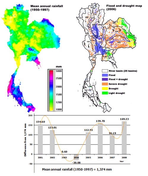
Thailand has an average annual rainfall of over 1,300 mm; however, some parts of the country continue to suffer drought problems due to the uneven distribution of rainfall. Thailand has frequently suffered from flood and drought as shown in Figure 3. Flooding usually occurs during the monsoon season (September-October) when there is intense precipitation. Drought (mainly water shortages for irrigation purposes) occurs in summer or when rainfall is delayed in the early part of the rainy season (July). Some particular areas experience both flooding and drought conditions in a single year, due to temporal and spatial uncertainties in the monthly rainfall or the poor management of the conveyance infrastructure. The common practice in Thailand is to manage the risks after considering which areas are likely to be vulnerable to either flood or drought. Failure to manage risk by addressing one aspect at a time can lead to adverse results; for example, importing water from other basins to boost water supply multiplies the risk of flooding in the downstream area. This approach is not favorable because the country would have to spend on redundant investments in importing water and on flood protection measures. Therefore, managing flood and drought risks is a new challenge in Thailand and is becoming increasingly important as a result of global warming.
Figure 3 (Left) The distribution of annual rainfall averaged from 1950 to 1997; (Right) flood and drought map in 2006; and (Bottom) recent changes (2001-2008) in the amount of annual rainfall in Thailand
This paper presents a risk management approach for the sustainable development of water resources by taking flood and drought risks, as well as climate change, into account in the planning process. Then, regional and sub-regional spatial strategies can be identified to ensure that risks do not increase and to prevent duplicating investments. The risk assessment will categorize an area to be regarded as vulnerable according to one of the three types of risks i.e. flood risk, drought risk and combined risk. Therefore, this will enable suitable policies and local measures to be chosen according to the different types of local risks.
I. Risk Management of Water Resources in Thailand
1.1 Risk management framework
The risk management framework involves collecting information, establishing the context, identifying the risks, assessing the risks, and treating the risks (Figure 4). At each step, stakeholders should communicate, review and monitor the progress and performance of the management framework.
Figure 4 Risk management framework

The impact of climate change needs to be addressed when establishing the context and must continue to be considered throughout the risk management framework. The major source of risk in water resources, especially water supply, is rainfall. We cannot control where, when, and how much it will rain, and these factors are what causes flooding and drought risks. These risks pose a threat to economic development, from rain-fed agriculture to water utilization in the industrial sector. As for flooding threats, the highest loss was 13,385 million Baht in 2002 , with a total of 72 provinces affected.
1.1.1 Risk assessment
Risk assessment features an analysis of the types of risk in an area, the time of year when the risk is likely to occur, its potential severity, and the likelihood of it occurring. This article focuses only on the physiographical assessment of risk, whereas the bigger picture includes the additional evaluation of social, economic, and environmental factors.
Traditional methods of risk assessment such as rainfall analysis, flood and risk map creation, and water balance (the balance of water supply and demand) have often been conducted on an annual basis and are statistically-based. There is a danger with examining the risks on an annual basis, since flooding and drought problems take place over a shorter time period. The annual water balance may conceal either problem since the total annual water supply may exceed annual demand, but, in any particular month, demand may overshoot the supply and vice versa. This is very likely because the monsoon season begins in May; however, from July to August, sporadic low precipitation is often experienced, followed by intense rainfall in September and October over most parts of Thailand.
Statistically-based studies of flooding and drought risks frequently exclude the consideration of spatial and temporal climate variability; an average is usually reported. For example, the nationwide average precipitation for 2008 was 1,543 mm, 5% higher than the value in 2007. If we look at the country as a homogenous area, a 5% difference seems very insignificant. However, if we account for spatial variations in rainfall, the outcome can be dramatically different. The 2008 precipitation in the east was 16% higher than the 2007 value; in contrast, the 2008 precipitation in the south was 10% lower than the 2007 value. In terms of temporal variability, the average annual value hides inter-annual fluctuations and could lead to faulty interpretations about the water situation, especially if the figure is further used in the operation of reservoirs or resource management. For instance, in 1993-2004, the Tab Ma sub-basin in Rayong province had an average annual stream flow of 95 mm3. If the inter-annual variation in stream flow is only 5%-10%, there may be no need to have a secondary or emergency water storage facility because of the very low uncertainty in the amount of water supply (HAII, 2008-a). However, the actual findings show that the inter-annual variability can be as high as 30%, emphasizing the need for water storage as part of the risk management. With climate change, we do not know precisely the magnitude of the changes or their associated impacts, but we can be sure that the uncertainty of spatial and temporal variability will rise.
Another drawback of the conventional method is that flood and drought matters are mostly handled separately. So, in places where both problems arise, redundant investments are inevitable.
We propose adopting an innovative approach to risk assessment which relies on monthly analysis, is physically-based, and accounts for the spatial heterogeneity of a basin. This means that the analysis is done on a sub-basin level, rather than considering a basin as one big homogenous system. After analysis, our purpose is to mitigate risks by initiating policies and measures that are tailor-made for individual areas.
Assessment of the monthly water balance, coupled with a scenario analysis of water supplies, is proposed for the risk assessment. Drought conditions occur when estimated demand is higher than water supply; conversely, flooding takes place when the water supply exceeds river or reservoir storage capacity. The unique combination of these analyses provides us with three key answers.
- Types of local risk
- Risk timeframes: We find that both flooding and drought occur in several sub-basins. In the north-east, the risk of drought exists in June and July whereas the risk of flooding is highest in September and October
- Level of threats: Not only can we understand the type of risk, but we also can quantify the potential severity, of both water shortages and the volume of flood water
The scenario analysis of the monthly water supply, specifically rainfall or stream flow, helps us analyze the climate pattern in each situation, from wet years, average years, to dry years. In addition, we can calculate the likelihood of risk.
The last step is to assign a ranking for each sub-basin as a means to prioritize the risk treatment.
1.1.2 Risk treatment
Typical risk treatment techniques include avoidance, reduction, transfer, and retention. Because the risk factors in water supply are not controllable, risk avoidance or total prevention is impossible. Water demand is another risk factor, with a focus on the supply side and particular emphasis on risk reduction.
The risk reduction framework consists of macro and micro-management (Figure 5). The setting of policies and measures should conform to this structure, and the impact of climate change shall be considered and integrated into the policies and their implementation.
II. Policy Making for Risk Management
Macro-management aims to handle inter-basin and basin management, with the responsible bodies being national and regional governmental agencies. The macro-management approach should target quantitative goals such as water security and water balance. Therefore, the policies and measures primarily involve the development of the main infrastructure such as large and medium-sized reservoirs, dams, and water distribution systems (Figure 6).
Micro-management aims at developing sub-infrastructure including secondary and emergency supply systems. Another important component is community water management. These local systems provide flexibility and act as a buffer against risks. Consequently, the measures are customized to the local situation such as the adjustment of water allocation, water usage efficiency and cropping patterns. Major stakeholders are local governmental agencies, cities, and communities. The key to success is the adaptive capability and the collaboration and participation of all parties.
Figure 5 Macro and micro-management as part of risk management

Figure 6 Tiers of water management system

In summary, the policies and measures which address risk management should consider both macro and micro-management, taking care of local as well as regional needs.
III. Case Study of the Risk Management and Policy Framework for the East Coast - Gulf Basin
Figure 7 The Eastern Seaboard of Thailand
 The Eastern Seaboard of Thailand (Figure 7) is home to several huge industrial estates, including the Mab Ta Phut Industrial Estate, whose focus is on petrochemicals and heavy industries, in Rayong province. The major sources of water supplying Mab Ta Phut are the Dok Krai, Nong Pla Lai, and Klong Yai reservoirs. The Eastern Seaboard of Thailand (Figure 7) is home to several huge industrial estates, including the Mab Ta Phut Industrial Estate, whose focus is on petrochemicals and heavy industries, in Rayong province. The major sources of water supplying Mab Ta Phut are the Dok Krai, Nong Pla Lai, and Klong Yai reservoirs.
In 2005, severe drought in the region led to a conflict in water resource allocation among the agricultural, industrial, and domestic consumption sectors. It was so severe that the industrial sector had to hunt for every drop of water from any sources it could find, including shipping water by truck from nearby regions. Imagine if the petrochemical industry was forced to suspend its operations for two months, how severe would the impact be on the country’s gross domestic product?
This issue highlights the importance of risk management for water security, not only in Rayong but also in the greater region. By conducting a risk assessment for the East Coast - Gulf Basin using the water balance and scenario analysis (HAII, 2008-b), we were able to create flood and drought risk maps (Figure 8). In this case, the Mab Ta Phut area typically has a risk of drought whereas two out of three areas (areas 3, 4 and 5 in Figure 8) supplying water to Mab Ta Phut have a severe drought risk and one of them also has a risk of flooding. Therefore, policy makers are advised that area 4, which has both flood and drought issues, should have the highest priority for management (Figure 9). Thus, the potential severity of drought and flood threats in individual sub-basins can be determined and local measures suggested, based on the magnitude of the severity (Table 1).
Figure 8 Flood (a) and drought (b) risk maps of the East Coast - Gulf Basin

Figure 9 Ranking of priority based on the area’s flood and drought risk level

Table 1 Quantitative analysis of flood and drought severity and proposed measures to reduce risks
| Area |
Maximum water shortage
(mm3) |
Maximum oversupply
(mm3) |
Measures |
|
Irrigated |
Rain-fed |
All areas |
Local measures |
Regional measures |
| 1. West Rayong basin - Mab Ta Phut |
1.21 |
16.29 |
46 |
Development of new reservoirs; development of water distribution system |
Conservation of headwaters and use of check dams;
community water management |
| 2. Klong Yai basin below 3 reservoirs |
No problem |
32.04 |
226 |
Retention basins;trans-boundary water transfer;adjustment of cropping calendar |
Rehabilitation of water resources |
| 3. Klong Yai basin above Klong Yai Reservoir |
2.06 |
26.40 |
34 |
Development of new reservoirs; development of water distribution system |
Conservation of headwaters and use of check dams;
community water management
|
4. Klong Yai basin above Nhong Pla Lai Reservoir
|
4.06 |
43.33 |
52 |
Cascade reservoirs;
increase in water reservation capacity; development of new reservoirs; development of water distribution system; retention basins;adjustment of cropping calendar |
Rehabilitation of water resources |
| 5. Klong Yai basin above Dok Krai Reservoir |
3.39 |
36.17 |
37 |
Trans-boundary water transfer; development of new reservoirs;
development of water distribution system
|
Conservation of headwaters; rehabilitation of water resources; community water management |
IV. Conclusions
Risk management of water resources is analogous to business risk management. The process is comprised of an organized framework to manage the uncertainty or threats and involves federal and local agencies following procedures and using tools or measures conforming to the risk management policies. Risk and uncertainty in the water supply arena is due to rainfall, and the threats or factors which we cannot control are place, time and the volume of water. These factors cause drought or flood problems on different scales of severity.
One finding for Thailand is that there are several areas, especially in north-eastern Thailand, where both drought and flood occur in the same location. This information tells us that we need to devise solutions that can solve both drought and flood problems; otherwise, it may result in conflicting strategies that could potentially undermine each other’s effectiveness. A comprehensive understanding of the nature of the problems and their potential severity helps in risk management planning and investment in flood/drought mitigation. This is truly crucial in this era of climate change as it leads to greater variations in the climate pattern and, potentially, higher flood or drought risks and threats. Macro and micro-management provide a portfolio of primary, secondary, and emergency systems to act as a buffer against the impact of climate change.
Only when we achieve security in water resource management will we gain sustainability in Thai economic growth.
References
IPCC (Intergovernmental Panel on Climate Change), 2008: Climate Change and Water, IPCC Technical Paper VI
HAII (Hydro and Agro Informatics Institute), 2008-a: The technical feasibility study of Tabma as a retention basin in Rayong province
HAII (Hydro and Agro Informatics Institute), 2008-b: Study of the National Water Policy Framework, Parliament House, Thailand
|