Summary of the situation and key facts from the 2011 Great Flood

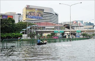
In 2011, Thailand faced the most severe flood in its history, beginning early in the year and persisting until the year's end. Affected areas were widespread across all regions of the country, especially in the North and the Central where severe flooding lasted for several months. Bangkok and its vicinity experienced the worst flooding in 70 years since the major flood of 1942. This flood caused immense damage to agriculture, industry, economy, and society, with cascading effects on many other sectors as well.
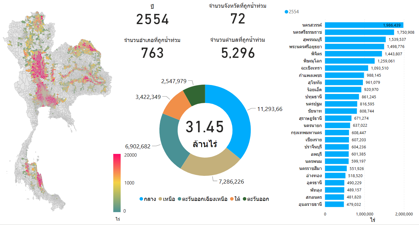
The Department of Disaster Prevention and Mitigation reported the damage from this historic flood. A total of 74 provinces were affected, including 844 districts, 5,919 sub-districts, and 53,380 villages. Approximately 16,224,302 people from 5,247,125 households were affected with 1,026 fatalities and 33 injuries. 2,632 houses were completely destroyed, while 477,595 houses were partially damaged. Additionally, 4,011 commercial buildings, 1,823 factories, and 4,563 temples/schools were affected. The disaster also damaged 2,263,408 livestock and 11,798,241 rai of agricultural land. The total damage was estimated at approximately 23,839 million baht. An analysis of flooded areas from satellite imagery revealed that in 2011, Thailand had approximately 31.45 million rai of flooded areas, distributed across all regions of the country, covering 72 provinces, 763 districts, and 5,296 sub-districts.
The Department of Disaster Prevention and Mitigation reported the damage from this historic flood. A total of 74 provinces were affected, including 844 districts, 5,919 sub-districts, and 53,380 villages. Approximately 16,224,302 people from 5,247,125 households were affected with 1,026 fatalities and 33 injuries. 2,632 houses were completely destroyed, while 477,595 houses were partially damaged. Additionally, 4,011 commercial buildings, 1,823 factories, and 4,563 temples/schools were affected. The disaster also damaged 2,263,408 livestock and 11,798,241 rai of agricultural land. The total damage was estimated at approximately 23,839 million baht. An analysis of flooded areas from satellite imagery revealed that in 2011, Thailand had approximately 31.45 million rai of flooded areas, distributed across all regions of the country, covering 72 provinces, 763 districts, and 5,296 sub-districts.
Facts and Causes of the Flood
1. Weather conditions and rainfall
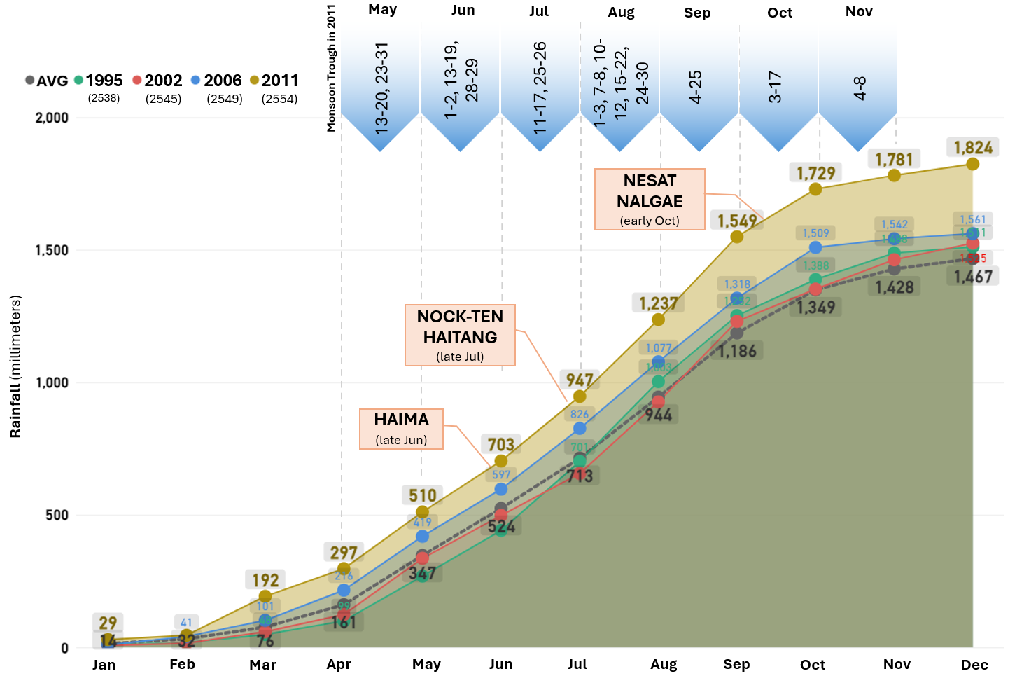
In 2011, rain came early and was significantly above normal. Above-average rainfall occurred almost every month with heavy rainfall starting in March, which was considered unusually early. The total annual rainfall reached 1,826 millimeters, which was 25% above normal, and higher than 1995, 2002, and 2006 when Thailand faced severe floods. Additionally, heavy rainfall patterns in 2011 were more widespread than in other years, particularly in the North where heavy rain occurred in almost all areas of the region. This was a major cause of the severe flooding, as most of the water from the North flowed downstream to the Central, which is a low-lying area with higher chances of flooding compared to other regions. The three main factors contributing to heavy rain in 2011 were:
- Five storms affecting Thailand consisted of 1) Tropical storm “NOCK-TEN”, which moved towards Nan Province, Thailand while weakening into a depression, 2) Tropical storm “HAIMA”, 3) Tropical storm “HAITANG”, which decayed into a low-pressure area before moving into Thailand, 4) Typhoon “NESAT”, and 5) Typhoon “NALGAE”, which affected Thailand with increased rainfall despite dissipating over Vietnam.
- Monsoon troughs persisted over Thailand from May to November, especially in upper and central Thailand where each occurrence lasted for a long time. During August and September, the monsoon troughs persisted almost throughout the entire month. This resulted in heavy rains and floods in several areas.
- The La Niña phenomenon caused Thailand to have an increased rainfall trend. During the great flood event of 2011, La Niña began in mid-2010 and continued until mid-2011 with strong intensity in late 2010. After that, it weakened to moderate and weak La Niña conditions in early 2011. The conditions then shifted to neutral during June and July, before returning to weak and moderate La Niña states again from August 2011 until March 2012. This resulted in above-normal rainfall in Thailand, especially from late 2010 to mid-2011. Furthermore, it caused heavy rainfall starting from March in 2011, which was earlier than usual. Normally, heavy rainfall in Thailand begins in May.
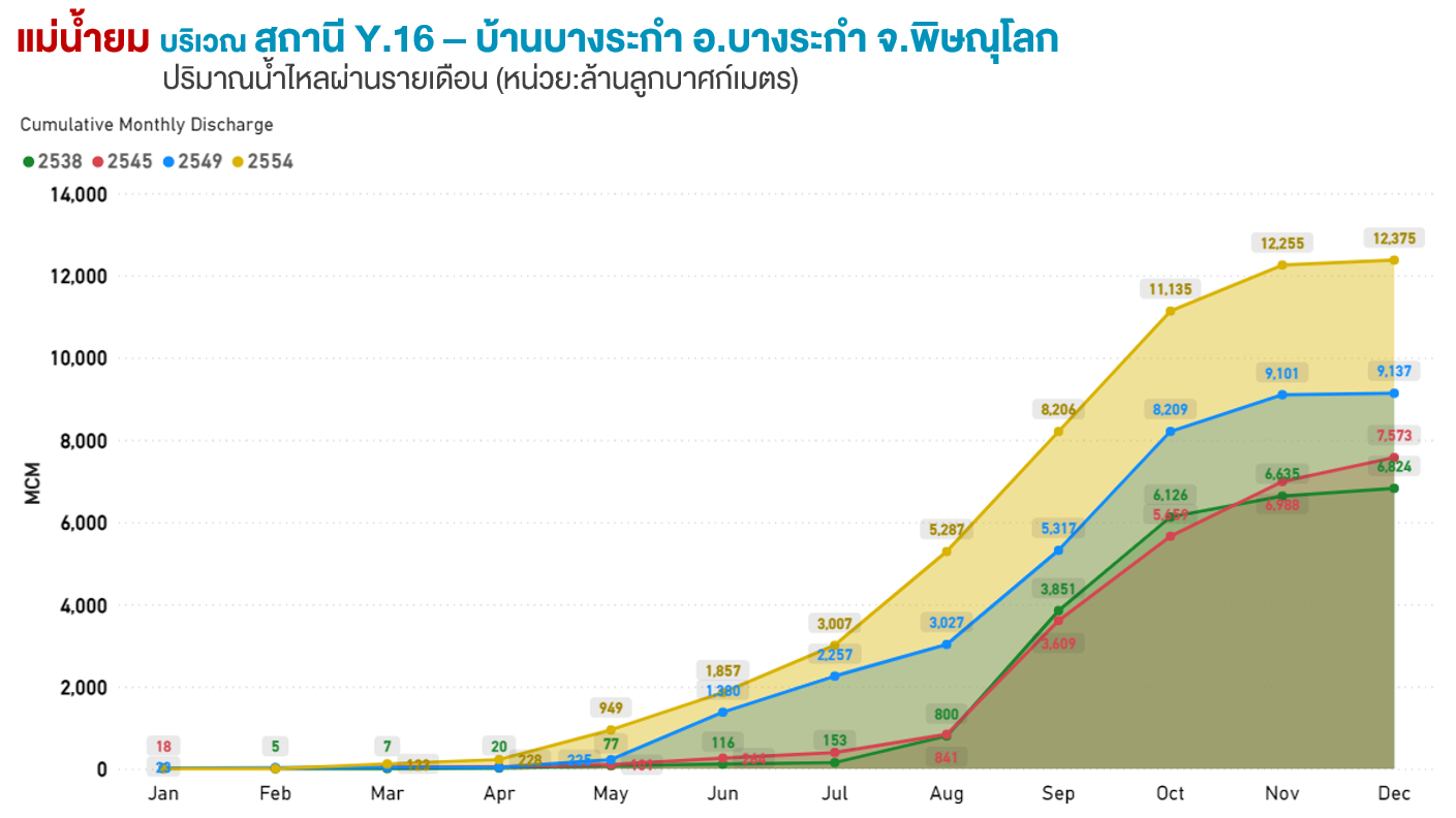
Graph of accumulated monthly rainfall throughout the year 2011 and factors causing heavy rains
2. Water quantity in dams and rivers
2.1 Historical excess water in dams but inefficient water release
In 2011, Thailand experienced above-average rainfall in many areas of the country, resulting in large volumes of water flowing into all 33 large dams. Throughout the year, the total inflow of all the dams reached a record high of 71,769 million cubic meters (mcm). Bhumibol, Sirikit, and Pasak Cholasid dams were particularly crucial factors affecting the flood situation in the North and the Central. In 2011, these three dams received higher inflow than in 1995 and 2006 when Thailand experienced major floods.
Most of the country’s dams received excessive inflow but they faced periodic obstacles in releasing water, especially the problem of flooding in downstream areas of dams due to heavy rains and high tides which prevented water releases at full capacity. As a result, 21 of all 33 dams experienced overflow (water levels exceeded their normal reservoir levels). Although the Bhumibol and Sirikit dams did not overflow, they had to urgently release water through their spillways, which was not a frequent occurrence for these two dams.
Even though several dams faced obstacles in releasing water, continuous water release was necessary due to the water volume exceeding the dams’ capacity. The release rates were periodically increased and decreased as appropriate to the situation.
In summary, the total water released from all dams throughout the year was 56,241 million cubic meters, which reached a record high, just like the annual inflow. Despite the high water release, at the end of the year, the total water storage of all dams remained at 61,097 million cubic meters, accounting for 87% of their capacity, which was at a high water level with 37,591 million cubic meters of usable water. Three dams still overflowed including the Kiw Kho Ma Dam in Lampang Province, Mae Ngad Sombunchon Dam in Chiang Mai Province, and Lam Sae Dam in Nakhon Ratchasima Province. Additionally, 18 other dams had high water levels.
Picture of water levels and water release through the spillway of Bhumibol Dam during October 2011


2.2 Excessive water in rivers
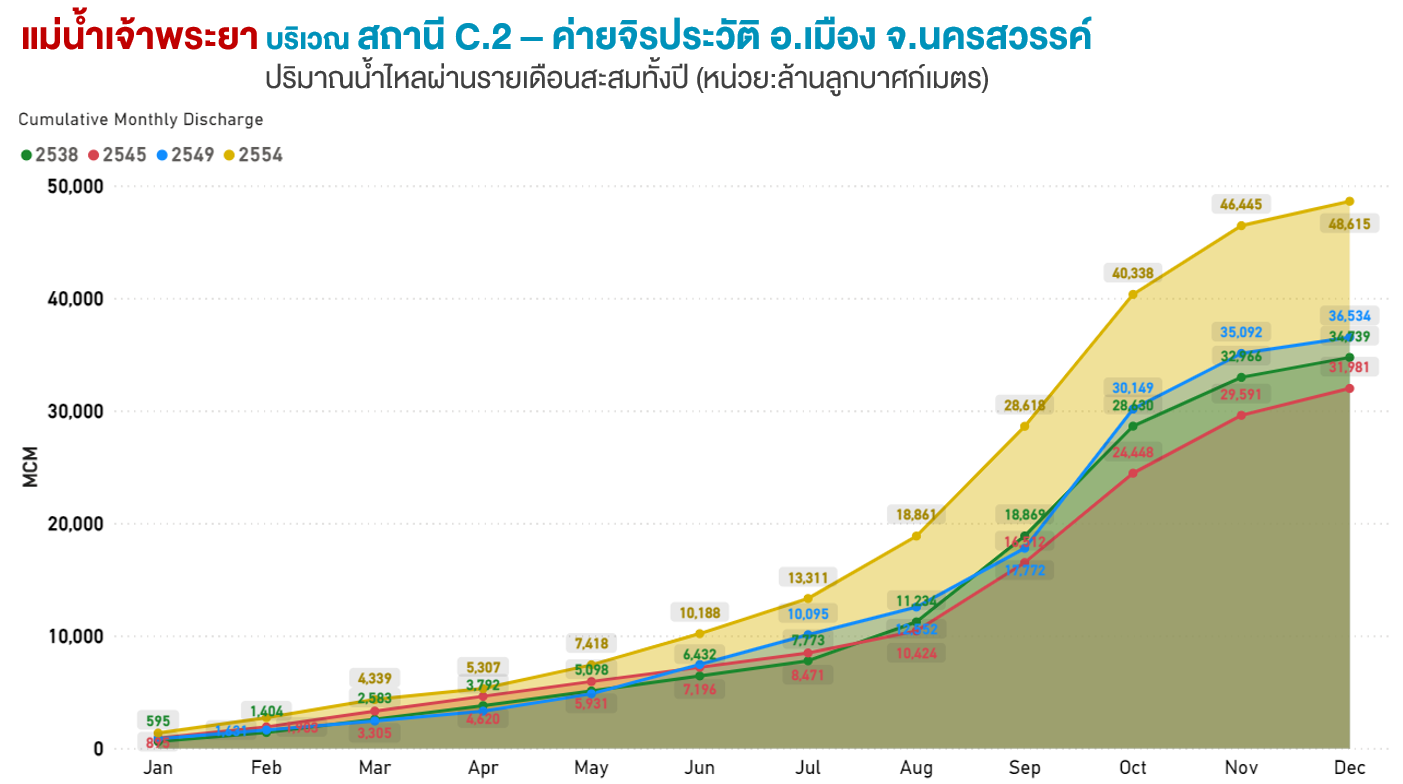
In 2011, almost all rivers in Thailand had significantly high water volume, particularly the Chao Phraya River Basin which faced the highest water volume in history. The high water events at key points were as follows:
• Station C.2 at Fort Chiraprawat, Muang District, Nakhon Sawan Province. This was the confluence of the Ping, Wang, Yom, and Nan rivers experiencing an unprecedented high water volume. In 2011, the total water volume reached 48,615 million cubic meters (mcm) which was significantly higher than in the years 1995, 2002, and 2006 when Thailand faced severe floods. This was due to all four headwater rivers also experiencing a lot of water in their history.
• Excessive water in Yom River, but unable to retain. This was a crucial factor contributing to the massive flood event of this year. The measurement of the downstream of Yom River in Bang Rakam District, Phitsanulok Province, before it flew into Chao Phraya River, showed a total annual water volume of 12,375 mcm, which was higher than in the years 1995, 2002, and 2006 when the Chao Phraya River basin faced severe flooding. Additionally, it was continuously higher from the beginning to the end of the year.
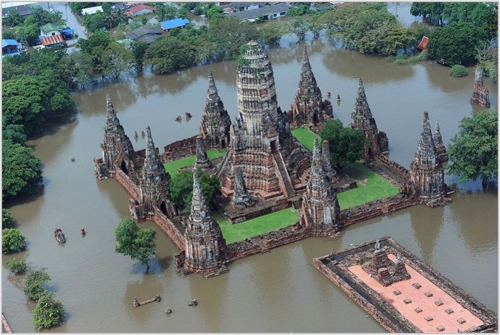
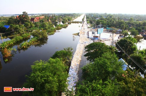
• Enormous inflow in Phranakhon Si Ayutthaya Province. Phranakhon Si Ayutthaya District, especially, received a large water volume from the Chao Phraya, Pasak, and Lop Buri rivers.
The satellite imagery of flooded areas in Phranakhon Si Ayutthaya Province, comparing between July and October 2011

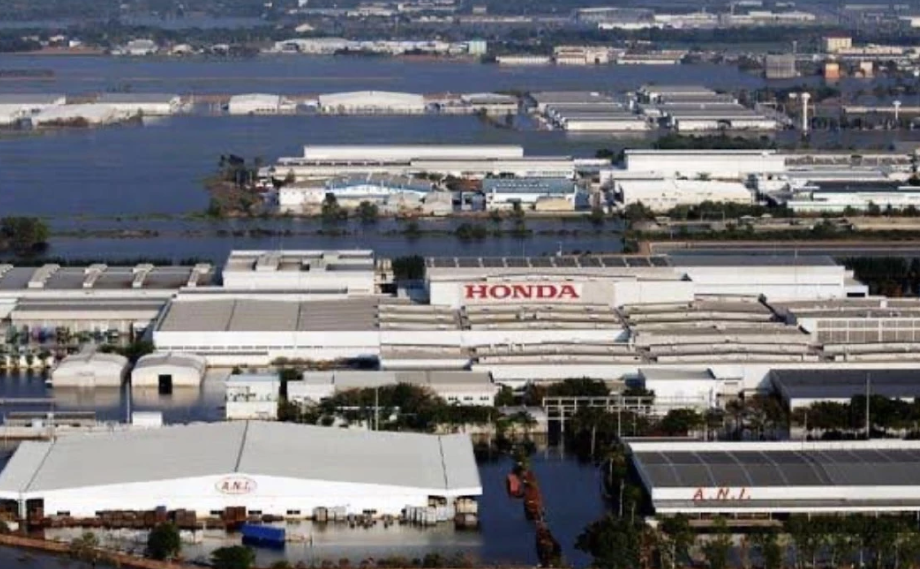
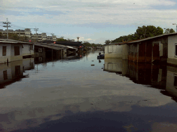
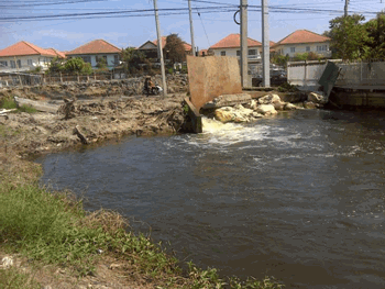
• Water overflowing through Klong Khao Mao Water Gate into Rojana Industrial Park. This was caused by the enormous water volume converging in Pranakhon Si Ayutthaya Province, resulting in excessive water flowing back into Klong Khao Mao, overflowing Klong Khao Mao Water Gate, and entering Rojana Industrial Park. It then combined with the overflow from the Pasak River before flowing into Navanakorn Industrial Estate, Bangkradi Industrial Park, and finally into the northern area of Bangkok.
Picture of flooding at Rojana Industrial Park
Picture of water flowing from Navanakhon
towards Rangsit on 20 October 2011
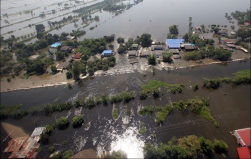
towards Rangsit on 20 October 2011
2.3 High tides: a major obstacle to efficient water drainage
During late October, mid-November, and late November 2011, high tides occurred in the Gulf of Thailand, making it increasingly difficult to drain water into the Gulf of Thailand. Consequently, several areas remained flooded for an extended period, especially in the lower Central where flooding persisted for several months. According to water level measurements by the Hydrograph Department of the Royal Thai Navy Headquarters station (Chao Phraya River mouth), the highest water level in late October was 2.53 meters on 30 October 2011. In mid-November, the highest water level was 2.41 meters on 12 November 2011. Another high tide occurred again in late November, but the water levels were lower than in late October and mid-November.
3. Area characteristics and water infrastructure
The important facts of area characteristics and water infrastructure contributing to the flooding in 2011 are as follows:
3.1 Limited water retention capacity of the Yom River Basin
In addition to the record high water level in the Yom River Basin as mentioned above, another critical issue was the lack of large dams or water retention areas with sufficient capacity to retard a large volume of water. As a result, almost all the water flowed downstream to the lower areas immediately, without any ability to control the volume.
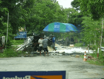
3.2 The collapse of the Bang Chom Sri water gate
This event resulted in excessive water flowing into Lopburi Province beyond its capacity. Consequently, the entire volume of water flowed back into the Phra Nakhon Si Ayutthaya District through the Lopburi River.
Photos of the damage at Bang Chom Sri Water Gate during the flooding in 2011


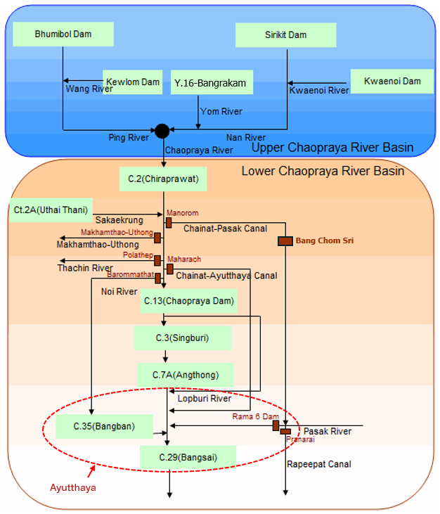
The schematic of the Chao Phraya River waterway, locations of key water gates and water stations
3.3 Reduced efficiency of flood prevention structures
This was caused by land subsidence, lack of maintenance, and changes in land use, especially in the retention areas of Bangkok that have been developed into residential and industrial zones. As a result, the water volume from the northern areas of Bangkok such as Lam Luk Ka District in Pathum Thani Province and Sai Mai District and Khlong Sam Wa District in Bangkok could not be drained through canals to the seaside pumping stations.
3.4 Water structures lacking the flexibility to cope with current rainfall situations
Due to the high variability of current rainfall situation in terms of quantity, area, and time, it was necessary to develop or rehabilitate water structures to cope with these changing rainfall patterns.
3.5 Inefficient drainage systems in Bangkok
There was an imbalance between the capacity of water delivered into the pumping stations and the capacity of the pumping stations themselves. While the pumping stations could pump out a lot of water, there was not enough water to pump because the water could not reach the pumping stations in time.
3.6 River and canal encroachment issues and lack of maintenance
Buildings and houses encroaching on waterways, as well as the lack of river and canal maintenance, resulted in inefficient water drainage, especially in Bangkok areas where major drainage canals such as Premprachakorn Canal and Lad Phrao Canal were encroached upon until only half their width remained.
Photo of a wastewater treatment pond blocking the waterway in Bangsue Canal
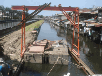
Photo of houses encroaching on waterways in Song, Bangbua, and Ladphrao canals
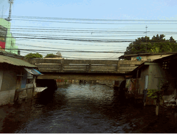
3.7 Problems from bridges obstructing water drainage
Oversized bridge piers, gaps between bridge piers not aligning with the water flow direction, and encroachment on spaces between bridge piers near riverbanks in almost all community areas obstructed water flow. The spaces of the piers at two banks of the canals were always encroached which blocked waterways. Only the space of the piers at the center of the bridge could be used for drainage.
Photo of Song-Bangbua-Lad Phrao canals showing houses encroaching on waterways under the bridge on both sides
3.8 Problems from individual construction of water barriers and dikes
Local people and small organizations independently constructed their own barriers and dikes without overall integration. This resulted in drainage issues and inefficient water drainage.
Photo of villagers in the Ban Mai Canal area using steel sheets to block the floodwater from entering their properties
3.9 Degradation of upstream forest areas.
Forest quality, especially in upstream areas, has significantly deteriorated, This caused low efficiency in water absorption and flow retardation.
3.10 Neglect and encroachment of water retention areas in the lower North
Important water retention areas in the lower northern region such as Bueng Boraphet in Nakhon Sawan Province and Bueng Si Fai in Phichit Province face neglect and encroachment, This reduced their capacity and ability to efficiently retard water.
4. Water Management
4.1 Problems of water diversion on eastern and western banks of the Chao Phraya River
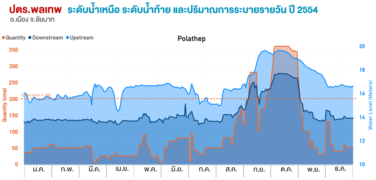
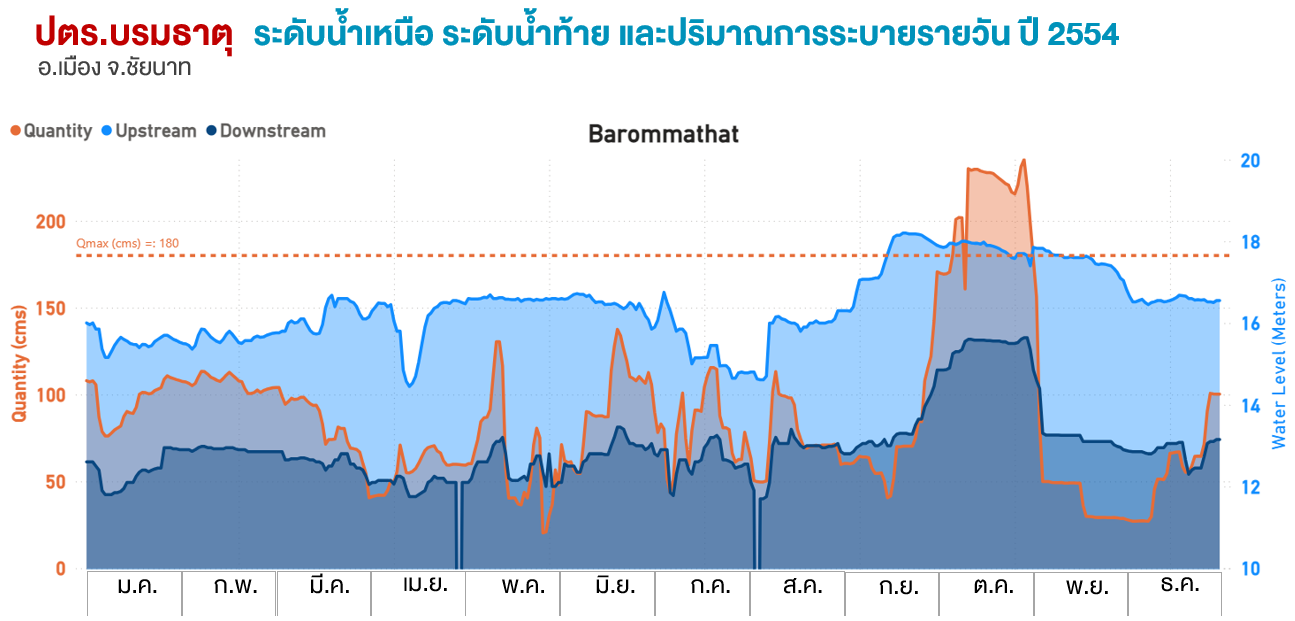
Water drainage on the eastern and western sides of the Chao Phraya River did not operate at full capacity, for example, the Polathep and Barommathat water gates could not be fully opened to divert water into the western floodplains. Sometimes, even though the upstream water level of the gates increased significantly, the discharge rate was reduced, especially in September. And although the discharge rate was increased at certain times, the water volume had to be limited to the river channel to prevent more widespread and more severe flooding.
4.2 Problems of water diversion into floodplains
Water management using floodplains as retention areas (monkey cheeks) for retarding floodwaters could not be managed efficiently.
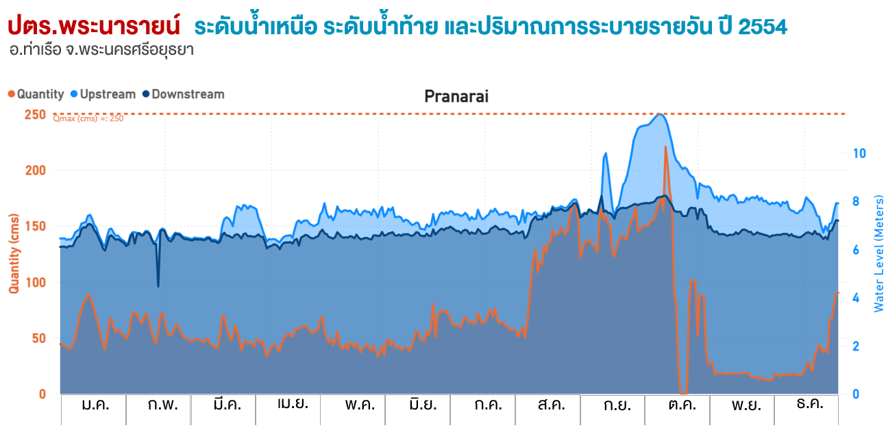
4.3 Phra Narai Water Gate not releasing water at full capacity
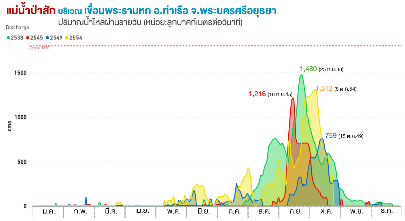
A large amount of water released from the Pasak Cholasid Dam flowing towards the Rama VI Dam was not diverted into the South Rapeepat Canal through Phra Narai Water Gate at full capacity. As a result, most of the water flowed along the Pasak River into Phra Nakhon Si Ayutthaya District via Rama VI Dam.
4.4 Water management issues in the Rapeepat Canal
The Rapeepat Canal had a high water volume but could not divert the water into the eastern floodplains. Conversely, plantations and farms in the eastern floodplain areas were pumping water into the Rapeepat Canal, causing the canal to receive an excessive amount of water.
Photo of water pumping from tributaries, plantations, and farms into the Rapeepat Canal
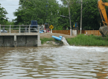
Photo of water pumping from tributaries, plantations, and farms into the Rapeepat Canal
The Rapeepat Canal on 23 October 2011
4.5 Delays in decision-making due to overlapping agencies
Problems of decision-making on water management, especially in terms of water diversion and drainage, to prevent flood disasters, often occurred at the boundaries of areas under different agencies' responsibility.